Da CastelluccioFrom Castelluccio
~10
minuti d'autominutes by car
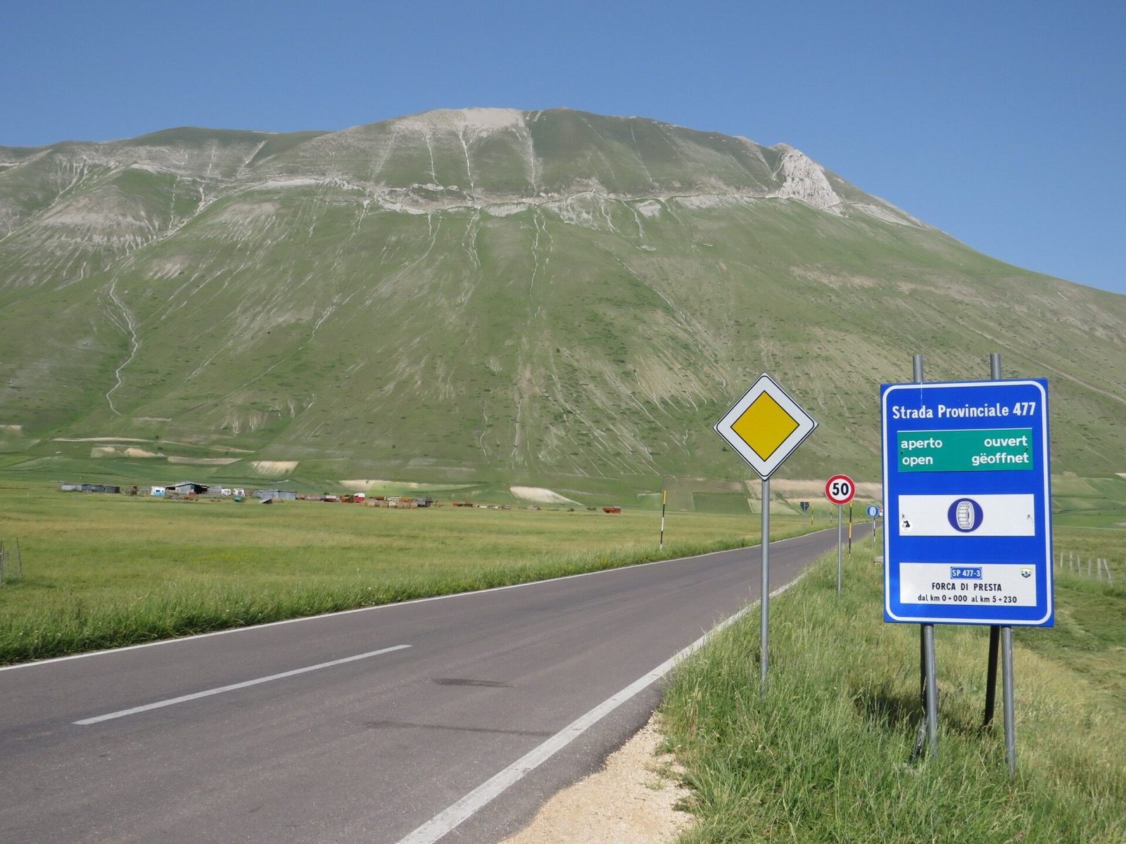
Il valico a 1.536 metri ai piedi del Monte Vettore, l'imbocco del sentiero più battuto per la vetta. Qui sotto le risposte che servono davvero: dove parcheggiare, come arrivarci, il Rifugio Belvedere, dove mangiare e quali sentieri partono da qui.The pass at 1,536 m at the foot of Mount Vettore, the start of the most-walked route to the summit. Below, the answers that actually matter: where to park, how to get there, the Rifugio Belvedere, where to eat and which trails begin here.
Forca di Presta sta a 1.536 metri ed è l'imbocco di una montagna vera, il Vettore. Su questa pagina trovi solo dati che possiamo verificare: non pubblichiamo previsioni meteo, orari o tariffe inventati. Dopo il sisma del 2016 alcuni sentieri e accessi (in particolare verso il Lago di Pilato) sono soggetti a ordinanze che cambiano. Per lo stato della strada, dei sentieri e degli accessi usa i canali ufficiali linkati qui sotto — Parco Nazionale dei Monti Sibillini, Comune di Arquata del Tronto, CAI — sono l'unica fonte che vale nel momento in cui parti. Forca di Presta sits at 1,536 m and is the gateway to a serious mountain, the Vettore. This page carries only figures we can verify: we do not publish invented forecasts, timetables or prices. Since the 2016 earthquake, some trails and access points (particularly toward Lake Pilato) are subject to changing ordinances. For road, trail and access status, use the official channels linked below — the Sibillini Mountains National Park, the Comune di Arquata del Tronto, the CAI — the only source that counts at the moment you set off.
Forca di Presta è un valico dei Monti Sibillini ai piedi del Monte Vettore, sul confine tra due regioni: divide la provincia di Ascoli Piceno (Marche), nel comune di Arquata del Tronto, dalla provincia di Perugia (Umbria) e dai Piani di Castelluccio. È uno dei valichi d'accesso all'altopiano, e insieme uno dei punti di partenza escursionistici più famosi dell'Appennino centrale.Forca di Presta is a Sibillini pass at the foot of Mount Vettore, on the border between two regions: it divides the province of Ascoli Piceno (Marche), in the municipality of Arquata del Tronto, from the province of Perugia (Umbria) and the Castelluccio plateaux. It is one of the gateways to the tableland, and one of the best-known hiking trailheads in the central Apennines.
Ci si arriva solo con mezzi propri: non c'è una linea di trasporto pubblico ordinaria che serva il valico. Da Castelluccio di Norcia sono circa dieci minuti d'auto lungo la strada dell'altopiano, che scende al Pian Grande e risale al valico verso il confine con le Marche. Dal versante marchigiano si sale da Arquata del Tronto e dalla Salaria.You can only get there by your own vehicle: no ordinary public transport line serves the pass. From Castelluccio di Norcia it is about ten minutes by car along the plateau road, which drops to the Pian Grande and climbs back to the pass toward the Marche border. From the Marche side you climb from Arquata del Tronto and the Salaria.
Il nome dice cosa è: forca è il valico, l'intaglio tra due versanti. Qui la strada tocca il punto più alto e la montagna si apre, con il Vettore che domina da nord.The name says what it is: forca means the pass, the notch between two slopes. Here the road reaches its highest point and the mountain opens up, with the Vettore looming to the north.
42°47′24″N · 13°15′39″E · 1.536 m
Tempi e distanze indicativi, su percorso in auto. Sono strade di montagna: i tempi reali dipendono da meteo, stagione ed eventuali ordinanze di accesso. La quota di 1.536 m è quella del nostro dataset.Times and distances are indicative, on a driving route. These are mountain roads: real times depend on weather, season and any access ordinances. The 1,536 m elevation is the figure from our dataset.
È la domanda che ci fate più di ogni altra, perché Forca di Presta è prima di tutto l'imbocco del Vettore: qui si lascia l'auto e si parte a piedi. Al valico c'è un ampio spiazzo di parcheggio, accanto al Rifugio degli Alpini, proprio dove comincia il sentiero per la vetta.It is the question you ask more than any other, because Forca di Presta is above all the gateway to the Vettore: here you leave the car and set off on foot. At the pass there is a large parking area, next to the Rifugio degli Alpini, right where the trail to the summit begins.
Non è un parcheggio a pagamento con sbarra: c'è la montagna. Nei giorni di bel tempo, e nei weekend d'estate, si riempie presto: se punti al Vettore o al Sentiero per Tutti, arriva al mattino. Se lo spiazzo è pieno si lascia l'auto lungo la strada, con buon senso e senza intralciare.There is no barrier-and-ticket car park: there is the mountain. On fine days, and on summer weekends, it fills up early: if you are aiming for the Vettore or the accessible trail, arrive in the morning. If the area is full you park along the road, sensibly and without blocking it.
Da giugno a luglio si aggiunge un secondo livello: nei weekend di fioritura ad accesso regolamentato, Forca di Presta è uno dei lotti di parcheggio in quota — insieme a Forca Canapine, Monte Prata e Scentinelle — da cui si prosegue in navetta verso l'altopiano. Lotti attivi, tariffe e orari cambiano ogni anno con l'ordinanza del Comune di Norcia, e non li riportiamo qui perché una cifra sbagliata ti rovina la giornata.From June to July a second layer applies: on regulated bloom weekends, Forca di Presta is one of the high-altitude parking lots — along with Forca Canapine, Monte Prata and Scentinelle — from which you continue by shuttle to the plateau. Active lots, fares and times change every year with the Comune di Norcia ordinance, and we do not reproduce them here because a wrong figure would ruin your day.
→ Accesso, navette e regole sui Piani→ Access, shuttles and rules on the plateaux
Buona notizia: il Rifugio Belvedere, la baita in legno a circa 1.577 metri al valico, ha riaperto nella primavera del 2026 dopo oltre due anni di chiusura. È gestito dall'associazione L'aria dei Sibillini ed è insieme un punto di ristoro, un presidio di sicurezza e il traguardo del Sentiero per Tutti, un percorso accessibile che porta in quota senza barriere architettoniche.Good news: the Rifugio Belvedere, the wooden lodge at about 1,577 metres at the pass, reopened in spring 2026 after more than two years closed. It is run by the association L'aria dei Sibillini and is at once a refreshment point, a safety outpost and the destination of the Sentiero per Tutti ("trail for all"), a barrier-free accessible path that reaches altitude.
Gli orari annunciati alla riapertura: aperto tutti i giorni da giugno a settembre, e nei weekend e giorni festivi da ottobre a maggio su prenotazione, condizioni meteo permettendo. Sono orari di un rifugio in quota: dipendono dal tempo, e conviene contattare la gestione prima di salire per la conferma del giorno, per il ristoro e per i servizi disponibili — che alla riapertura non sono stati dettagliati fonte per fonte.The hours announced at reopening: open daily from June to September, and on weekends and public holidays from October to May by reservation, weather permitting. These are the hours of a high-altitude refuge: they depend on the weather, and it is worth contacting the management before you go up to confirm the day, the catering and the services available — which were not spelled out source by source at reopening.
Lo storico Rifugio degli Alpini, sempre al valico e proprio all'imbocco del sentiero del Vettore, è invece chiuso dal terremoto del 2016. La regola operativa resta prudente: a Forca di Presta sali con acqua e pranzo al seguito, oppure fermati a Castelluccio di Norcia, a una decina di minuti d'auto.The historic Rifugio degli Alpini, also at the pass and right at the start of the Vettore trail, is by contrast closed since the 2016 earthquake. The prudent rule stands: come up to Forca di Presta with your own water and lunch, or stop in Castelluccio di Norcia, about ten minutes' drive away.
→ Rifugio Belvedere · Archivio Rifugi Sibillini→ Rifugio Belvedere · Sibillini Refuges archive
Orari e servizi in quota cambiano con il meteo e la stagione: verifica con la gestione prima di contare sul rifugio per mangiare.Hours and services at altitude change with weather and season: check with the management before counting on the refuge for lunch.
Forca di Presta è la partenza del sentiero più battuto per il Monte Vettore (2.476 m), il tetto dei Sibillini. Dal parcheggio il percorso sale con circa 900 metri di dislivello e richiede indicativamente 2,5-3 ore in salita, passando per il crinale e per il bivacco Tito Zilioli, poco sotto la cresta.Forca di Presta is the start of the most-walked route to Mount Vettore (2,476 m), the roof of the Sibillini. From the car park the trail climbs about 900 metres of ascent and takes roughly 2.5-3 hours uphill, passing the ridge and the Tito Zilioli bivouac just below the crest.
Il vecchio rifugio Zilioli, costruito nel 1960, fu distrutto dal sisma del 2016; al suo posto il CAI di Ascoli Piceno ha inaugurato nel 2020 un nuovo bivacco, utilizzabile da primavera ad autunno e non pensato per l'inverno. È un ricovero, non un rifugio con servizio: anche qui, ci si porta tutto.The old Zilioli refuge, built in 1960, was destroyed by the 2016 quake; in its place the CAI of Ascoli Piceno inaugurated a new bivouac in 2020, usable from spring to autumn and not intended for winter. It is a shelter, not a staffed refuge: here too, you carry everything.
È montagna vera, non una passeggiata. Servono scarponi, attrezzatura adeguata e attenzione al meteo, che al Vettore cambia in fretta. E prima di partire verifica lo stato dei sentieri: dopo il sisma del 2016 alcuni tratti e accessi — in particolare la discesa al Lago di Pilato dal lato di Foce di Montemonaco — sono stati soggetti a ordinanze e chiusure che nel tempo sono cambiate. Non le inventiamo: te le dicono il Parco e i Comuni.This is a real mountain, not a stroll. You need boots, proper gear and attention to the weather, which changes fast on the Vettore. And before you set off, check the trail status: since the 2016 earthquake some sections and access points — particularly the descent to Lake Pilato from the Foce di Montemonaco side — have been subject to ordinances and closures that have changed over time. We do not invent them: the Park and the municipalities do.
→ Sentiero Forca di Presta - Vettore · CAI→ Forca di Presta - Vettore trail · CAI
→ Stato sentieri e chiusure · Parco Sibillini→ Trail status and closures · Sibillini Park
La risposta onesta è: dipende dal giorno. Il valico non ha una chiusura stagionale fissa da calendario che possiamo garantire una volta per tutte, ma a 1.536 metri neve e ghiaccio comandano. In inverno la strada può essere chiusa, o richiedere pneumatici invernali o catene a bordo, per poche ore come per giorni.The honest answer is: it depends on the day. The pass has no fixed seasonal closure on the calendar that we can guarantee once and for all, but at 1,536 m snow and ice are in charge. In winter the road can be closed, or require winter tyres or chains on board, for a few hours or for days.
Non pubblichiamo date di chiusura invernale né un meteo nostro: a queste quote un dato vecchio di sei ore è peggio di nessun dato. Se sali d'inverno, parti con l'auto attrezzata, guarda il bollettino la mattina stessa e considera che al valico il vento è quasi sempre più forte che a valle.We publish no winter closure dates and no weather feed of our own: at this altitude a six-hour-old reading is worse than none. If you go up in winter, set off properly equipped, check the bulletin that same morning, and reckon that wind at the pass is almost always stronger than down in the valley.
Da giugno a luglio, nei weekend di fioritura ad accesso regolamentato, valgono inoltre le ordinanze del Comune di Norcia sui Piani di Castelluccio, che cambiano ogni anno: in quei giorni Forca di Presta è un punto di parcheggio in quota, non un passaggio libero.From June to July, on regulated bloom weekends, the Comune di Norcia's ordinances on the Castelluccio plateaux also apply, and they change every year: on those days Forca di Presta is a high-altitude parking point, not a free through-route.
La strada del valico è a fondo stretto e di montagna: guida con prudenza, soprattutto nelle ore di punta della fioritura.The pass road is narrow and mountainous: drive carefully, especially at peak bloom hours.
Forca di Presta è un balcone e una porta. Da qui il Vettore domina a nord, e dall'altra parte si aprono i Piani di Castelluccio: la scala del Pian Grande — quindici chilometri quadrati di altopiano — si capisce solo vedendola dall'alto, prima ancora di arrivare al borgo.Forca di Presta is both a balcony and a gateway. From here the Vettore dominates to the north, and on the other side the Castelluccio plateaux open out: the scale of the Pian Grande — fifteen square kilometres of tableland — only makes sense seen from above, before you even reach the village.
È uno dei due valichi da cui si sale ai Piani insieme a Forca Canapine: due porte diverse sulla stessa fioritura.It is one of the two passes from which you climb to the plateaux, together with Forca Canapine: two different gates onto the same bloom.
Sì. Al valico c'è un ampio spiazzo di parcheggio, accanto al Rifugio degli Alpini, ed è il punto da cui parte il sentiero più battuto per il Monte Vettore: nei giorni di bel tempo si riempie presto, quindi conviene arrivare al mattino. Non è un parcheggio a pagamento con sbarra. Nei weekend di fioritura ad accesso regolamentato (giugno-luglio) Forca di Presta è inoltre uno dei lotti di parcheggio in quota da cui si prosegue con le navette verso i Piani di Castelluccio: regole e tariffe cambiano ogni anno con l'ordinanza del Comune di Norcia, verificale prima di partire.Yes. At the pass there is a large parking area, next to the Rifugio degli Alpini, and it is the point where the most-walked trail to Mount Vettore begins: on fine days it fills up early, so it is best to arrive in the morning. It is not a barrier-and-ticket car park. On regulated bloom weekends (June-July) Forca di Presta is also one of the high-altitude parking lots from which you continue by shuttle to the Castelluccio plateaux: rules and fares change every year with the Comune di Norcia ordinance, so check them before you leave.
Sì. Il Rifugio Belvedere, a circa 1.577 metri al valico, ha riaperto nella primavera del 2026 dopo oltre due anni di chiusura, gestito dall'associazione L'aria dei Sibillini. È aperto quotidianamente da giugno a settembre e nei weekend e giorni festivi da ottobre a maggio su prenotazione, condizioni meteo permettendo. Sta al termine del Sentiero per Tutti, un percorso accessibile senza barriere architettoniche. Per orari aggiornati, servizi ed eventuale ristoro conviene contattare la gestione prima di salire: gli orari in quota dipendono dal meteo.Yes. The Rifugio Belvedere, at about 1,577 m at the pass, reopened in spring 2026 after more than two years closed, run by the association L'aria dei Sibillini. It is open daily from June to September and on weekends and public holidays from October to May by reservation, weather permitting. It stands at the end of the Sentiero per Tutti, a barrier-free accessible path. For up-to-date hours, services and any catering, it is best to contact the management before you go up: hours at altitude depend on the weather.
Forca di Presta si trova a 1.536 metri sul livello del mare, secondo il nostro dataset. È uno dei valichi d'accesso ai Piani di Castelluccio, ai piedi del Monte Vettore (2.476 m). Per confronto: il borgo di Castelluccio di Norcia è a 1.452 metri, Forca Canapine a 1.541 metri.Forca di Presta stands at 1,536 metres above sea level, according to our dataset. It is one of the gateway passes to the Castelluccio plateaux, at the foot of Mount Vettore (2,476 m). For comparison: the village of Castelluccio di Norcia is at 1,452 m, Forca Canapine at 1,541 m.
Dal parcheggio di Forca di Presta il sentiero più battuto per il Monte Vettore (2.476 m) sale con circa 900 metri di dislivello e richiede indicativamente 2,5-3 ore in salita, passando per il crinale e per il bivacco Tito Zilioli. È un percorso di montagna, non una passeggiata: serve attrezzatura adeguata e attenzione al meteo. Prima di partire verifica lo stato dei sentieri sui canali del Parco Nazionale dei Monti Sibillini e del CAI, perché dopo il sisma del 2016 alcuni tratti e accessi (in particolare verso il Lago di Pilato) sono soggetti a ordinanze.From the Forca di Presta car park, the most-walked trail to Mount Vettore (2,476 m) climbs about 900 metres of ascent and takes roughly 2.5-3 hours uphill, passing the ridge and the Tito Zilioli bivouac. It is a mountain route, not a stroll: you need proper gear and attention to the weather. Before you set off, check trail status on the Sibillini Mountains National Park and CAI channels, because since the 2016 earthquake some sections and access points (particularly toward Lake Pilato) are subject to ordinances.
Al valico il riferimento è il Rifugio Belvedere, riaperto nel 2026: per menù, ristoro e orari conviene contattare la gestione, perché in quota dipendono dal meteo e dalla stagione. Lo storico Rifugio degli Alpini, al valico, è invece chiuso dal terremoto del 2016. Per un pasto sicuro conviene comunque salire con acqua e pranzo al seguito, oppure fermarsi a Castelluccio di Norcia, a una decina di minuti d'auto.At the pass the reference point is the Rifugio Belvedere, reopened in 2026: for menu, catering and hours it is best to contact the management, because at altitude they depend on the weather and the season. The historic Rifugio degli Alpini, at the pass, is by contrast closed since the 2016 earthquake. To be safe, come up with your own water and lunch, or stop in Castelluccio di Norcia, about ten minutes' drive away.
Ci si arriva solo con mezzi propri, non c'è trasporto pubblico ordinario al valico. Da Castelluccio di Norcia sono circa dieci minuti d'auto lungo la strada dell'altopiano che scende al Pian Grande e risale al valico, verso il confine con le Marche e Arquata del Tronto. A 1.536 metri la percorribilità dipende da neve e ghiaccio: in inverno la strada può essere chiusa o richiedere pneumatici invernali o catene a bordo. Verifica sempre prima di partire.You can only get there by your own vehicle; there is no ordinary public transport to the pass. From Castelluccio di Norcia it is about ten minutes by car along the plateau road that drops to the Pian Grande and climbs back to the pass, toward the Marche border and Arquata del Tronto. At 1,536 m, passability depends on snow and ice: in winter the road may be closed or require winter tyres or chains on board. Always check before you leave.
Forca di Presta è una porta, non una destinazione isolata: da qui salgono i Piani di Castelluccio e parte il Vettore. La guida completa al borgo, alla fioritura, alle escursioni e all'accesso resta la home di castelluccio.org.Forca di Presta is a gateway, not an isolated destination: the Castelluccio plateaux rise from here and the Vettore begins here. The complete guide to the village, the bloom, the hikes and access remains the castelluccio.org home page.