Via normaleNormal route
~900
m dislivello · da Forca di Prestam ascent · from Forca di Presta
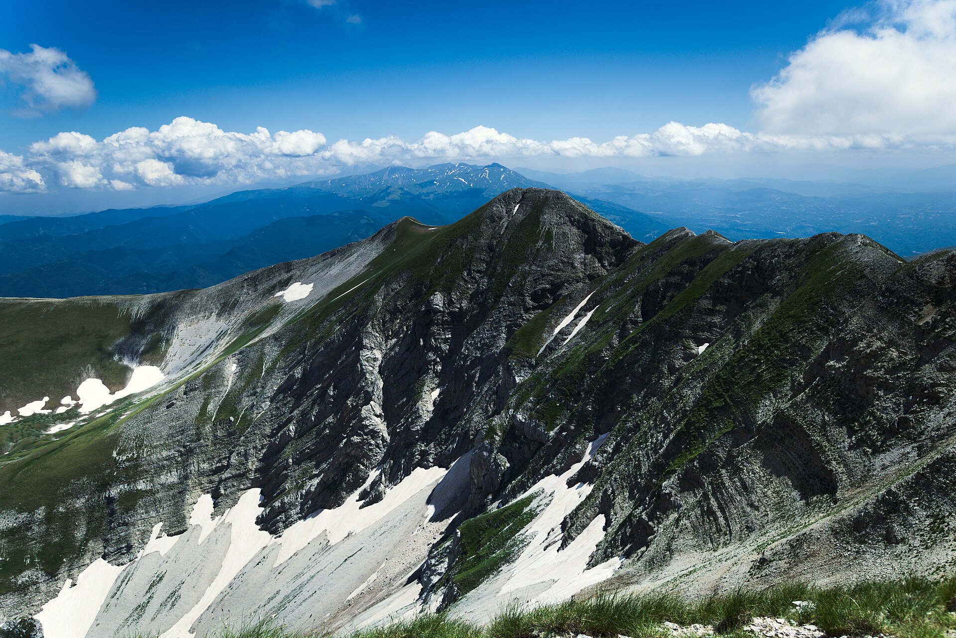
La vetta più alta dei Sibillini, 2.476 metri, sul confine tra Umbria e Marche. È alta montagna vera: la via normale da Forca di Presta è da escursionisti esperti. Qui sotto le risposte che servono davvero — come si sale, la difficoltà, la frattura del Redentore, il meteo — prima di mettere lo zaino in spalla.The highest peak of the Sibillini, 2,476 m, on the border between Umbria and Marche. This is a serious mountain: the normal route from Forca di Presta is for experienced hikers. Below, the answers that actually matter — how you climb it, the difficulty, the Redentore fracture, the weather — before you shoulder your pack.
Il Vettore non è una passeggiata. La via normale è un itinerario da escursionisti esperti (EE): la cresta finale è esposta, il meteo in quota cambia in fretta e qui ci sono stati incidenti anche mortali. Non si sale da soli, senza esperienza o senza attrezzatura adeguata. Su questa pagina trovi solo dati che possiamo verificare: non pubblichiamo meteo, tempi o stato dei sentieri inventati. Dopo il sisma del 2016 la frattura sulla cresta del Redentore e alcuni accessi (in particolare verso il Lago di Pilato) sono soggetti a ordinanze che cambiano. Per lo stato reale del sentiero e per il meteo del giorno usa i canali ufficiali linkati qui sotto — Parco Nazionale dei Monti Sibillini, CAI, Comuni — sono l'unica fonte che vale nel momento in cui parti. The Vettore is no stroll. The normal route is a path for experienced hikers (EE): the final ridge is exposed, the weather at altitude changes fast, and there have been fatal accidents here. You do not go up alone, without experience or without proper gear. This page carries only figures we can verify: we do not publish invented forecasts, times or trail status. Since the 2016 earthquake the fracture along the Redentore ridge and some access points (particularly toward Lake Pilato) are subject to changing ordinances. For real trail status and the day's weather, use the official channels linked below — the Sibillini Mountains National Park, the CAI, the municipalities — the only source that counts at the moment you set off.
Il Monte Vettore, 2.476 metri, è la vetta più alta dei Monti Sibillini e di tutto l'Appennino umbro-marchigiano. Sorge sul confine tra Umbria e Marche, tra il comune di Norcia (Perugia) e i comuni di Arquata del Tronto e Montemonaco (Ascoli Piceno), e domina dall'alto i Piani di Castelluccio: è il profilo che chiude l'orizzonte del Pian Grande, quello che si vede da tutto l'altopiano.Mount Vettore, 2,476 metres, is the highest peak of the Sibillini Mountains and of the entire Umbrian-Marchigian Apennines. It stands on the border between Umbria and Marche, between the municipality of Norcia (Perugia) and those of Arquata del Tronto and Montemonaco (Ascoli Piceno), and towers over the Castelluccio plateaux: it is the profile that closes the Pian Grande's horizon, the one you see from all over the tableland.
La cifra della quota merita una nota di onestà: noi riportiamo 2.476 metri, dal nostro dataset, ma diverse fonti indicano 2.478 metri. È una piccola discrepanza tra rilievi diversi, di un paio di metri, e non cambia la sostanza: è comunque il tetto dei Sibillini, la montagna più alta che si vede da quassù.The elevation figure deserves an honest note: we report 2,476 metres, from our dataset, but several sources give 2,478 metres. It is a small discrepancy of a couple of metres between different surveys, and it changes nothing substantial: this is still the roof of the Sibillini, the highest mountain you see from up here.
Sotto la cresta, sul versante di Montemonaco, si nasconde il Lago di Pilato, minuscolo lago glaciale carico di leggende. La montagna non è una meta da attraversare in fretta: è il cuore verticale del Parco.Below the ridge, on the Montemonaco side, lies the hidden Lake Pilato, a tiny glacial lake steeped in legend. This mountain is not a place to cross in a hurry: it is the vertical heart of the Park.
42°49′29″N · 13°16′29″E · 2.476 m
Quota, dislivello e tempi sono indicativi e vanno confrontati con le fonti ufficiali del Parco e del CAI prima di partire.Elevation, ascent and times are indicative and should be checked against the official Park and CAI sources before you leave.
La via più battuta parte dal valico di Forca di Presta (1.536 m), dove si lascia l'auto. Dal parcheggio il sentiero sale con circa 900 metri di dislivello e richiede indicativamente 2,5-3 ore in salita, passando per il bivacco Tito Zilioli, poco sotto la cresta.The most-walked route starts from the Forca di Presta pass (1,536 m), where you leave the car. From the car park the trail climbs about 900 metres of ascent and takes roughly 2.5-3 hours uphill, passing the Tito Zilioli bivouac just below the crest.
Dal bivacco si guadagna la cresta e si prosegue alla Cima del Redentore (2.448 m); da lì l'ultimo tratto in quota porta alla vetta del Vettore. Il vecchio rifugio Zilioli, del 1960, fu distrutto dal sisma del 2016: al suo posto il CAI di Ascoli Piceno ha inaugurato nel 2020 un bivacco, un ricovero non presidiato utilizzabile da primavera ad autunno, non pensato per l'inverno.From the bivouac you gain the ridge and continue to the Cima del Redentore (2,448 m); from there the last high stretch leads to the Vettore summit. The old Zilioli refuge, from 1960, was destroyed by the 2016 quake: in its place the CAI of Ascoli Piceno inaugurated a bivouac in 2020, an unstaffed shelter usable from spring to autumn and not intended for winter.
Non è un rifugio con servizio: ci si porta tutto. Dislivello e tempi qui sopra sono orientativi — dipendono dal passo, dal meteo e dalle condizioni del sentiero — e non sostituiscono la traccia ufficiale del CAI e del Parco, da consultare prima di partire.It is not a staffed refuge: you carry everything. The ascent and times above are indicative — they depend on your pace, the weather and trail conditions — and do not replace the official CAI and Park route, to be consulted before you set off.
→ Sentiero Forca di Presta - Vettore · CAI→ Forca di Presta - Vettore trail · CAI
→ Stato sentieri e chiusure · Parco Sibillini→ Trail status and closures · Sibillini Park
Diciamolo chiaro, perché è la cosa più importante di questa pagina: il Vettore è alta montagna. La via normale è classificata EE — per escursionisti esperti, la cresta finale è esposta e qui ci sono stati incidenti, anche mortali. Non è un percorso da improvvisare, da affrontare da soli o da inesperti, e non è una meta per chi cerca una passeggiata panoramica.Let us be blunt, because it is the most important thing on this page: the Vettore is high mountain terrain. The normal route is graded EE — for experienced hikers, the final ridge is exposed, and there have been accidents here, some fatal. It is not a route to improvise, to tackle alone or without experience, and it is not a destination for anyone after a scenic walk.
C'è poi un elemento specifico di questa montagna: il terremoto del 2016 ha aperto una frattura lungo la cresta della Cima del Redentore, proprio sul filo che porta alla vetta. Da allora alcuni tratti e accessi dell'area sono stati soggetti a ordinanze e chiusure che nel tempo sono cambiate.There is also an element specific to this mountain: the 2016 earthquake opened a fracture along the crest of the Cima del Redentore, right on the edge that leads to the summit. Since then some sections and access points in the area have been subject to ordinances and closures that have changed over time.
Non pubblichiamo qui lo stato del sentiero, perché cambia. Non ha senso leggere su una pagina web se un tratto è aperto o chiuso: quella informazione, se non è del giorno, è pericolosa. La verifichi solo alla fonte, prima di partire, sui canali ufficiali del Parco, del CAI e dei Comuni di Arquata del Tronto e Montemonaco.We do not publish the trail status here, because it changes. It makes no sense to read on a web page whether a section is open or closed: that information, if it is not from the same day, is dangerous. You check it only at the source, before you leave, on the official channels of the Park, the CAI and the municipalities of Arquata del Tronto and Montemonaco.
→ Ordinanze, sentieri e sicurezza · Parco Sibillini→ Ordinances, trails and safety · Sibillini Park
La finestra più adatta per la via normale è la piena estate, indicativamente da fine giugno a settembre, quando la neve è sciolta e le giornate sono lunghe. Anche allora, a queste quote il meteo cambia in fretta: la cresta è esposta al vento e ai temporali del pomeriggio, che sull'Appennino centrale si formano rapidi.The best window for the normal route is high summer, roughly from late June to September, when the snow has melted and the days are long. Even then, at this altitude the weather changes fast: the ridge is exposed to wind and to afternoon thunderstorms, which build quickly over the central Apennines.
La regola è quella di sempre in montagna: si parte presto, si guarda il bollettino la mattina stessa e si torna indietro se le condizioni peggiorano. La vetta non scappa; una tempesta in cresta sì, che è un problema serio.The rule is the timeless one of the mountains: start early, check the forecast that same morning and turn back if conditions worsen. The summit is not going anywhere; a storm on the ridge is a serious problem.
In inverno il Vettore è un'altra montagna: con neve e ghiaccio è terreno da alpinismo, non da escursionismo, e richiede attrezzatura e tecnica specifiche. Non è per chi non ha esperienza. Noi non pubblichiamo un meteo nostro: a queste quote un dato vecchio di sei ore è peggio di nessun dato.In winter the Vettore is a different mountain: with snow and ice it is alpine terrain, not hiking terrain, and it demands specific gear and technique. It is not for the inexperienced. We publish no weather feed of our own: at this altitude a six-hour-old reading is worse than none.
Se non sei un escursionista allenato ed esperto, la scelta più saggia è salire con una guida o preferire itinerari più bassi sui Piani. Il Vettore aspetta.If you are not a fit, experienced hiker, the wisest choice is to climb with a guide or opt for lower routes on the plateaux. The Vettore will wait.
Dai 2.476 metri della vetta lo sguardo corre lontano. A ovest, in basso, si aprono i Piani di Castelluccio: da quassù la scala del Pian Grande — quindici chilometri quadrati di altopiano — si capisce davvero, come una mappa vivente. Sotto la cresta, sul versante opposto, si nasconde il Lago di Pilato.From the summit's 2,476 metres the eye runs far. To the west, below, the Castelluccio plateaux open out: from up here the scale of the Pian Grande — fifteen square kilometres of tableland — finally makes sense, like a living map. Below the ridge, on the far side, lies the hidden Lake Pilato.
Nelle giornate limpide lo sguardo arriva fino all'Adriatico a est e al massiccio del Gran Sasso a sud: è uno dei balconi più ampi dell'Appennino centrale. Ma il panorama è il premio di una salita seria, non un motivo per sottovalutarla.On clear days the view reaches the Adriatic to the east and the Gran Sasso massif to the south: it is one of the widest balconies in the central Apennines. But the panorama is the reward of a serious climb, not a reason to underestimate it.
Il Monte Vettore è alto 2.476 metri secondo il nostro dataset ed è la vetta più alta dei Monti Sibillini e dell'Appennino umbro-marchigiano. Alcune fonti indicano 2.478 metri: è una piccola discrepanza tra rilievi diversi, entrambe le cifre sono in circolazione. Per confronto: Forca di Presta, da cui parte la via normale, è a 1.536 metri, e il borgo di Castelluccio di Norcia a 1.452 metri.Mount Vettore is 2,476 metres high according to our dataset and is the highest peak of the Sibillini Mountains and of the Umbrian-Marchigian Apennines. Some sources give 2,478 metres: it is a small discrepancy between different surveys, and both figures are in circulation. For comparison: Forca di Presta, where the normal route starts, is at 1,536 metres, and the village of Castelluccio di Norcia at 1,452 metres.
La via normale parte dal valico di Forca di Presta (1.536 m). Dal parcheggio il sentiero sale con circa 900 metri di dislivello, passa per il bivacco Tito Zilioli, raggiunge la Cima del Redentore (2.448 m) e prosegue in cresta fino alla vetta del Vettore. È un itinerario da escursionisti esperti (EE), indicativamente 2,5-3 ore in salita: dislivello e tempi sono orientativi e vanno confrontati con le fonti ufficiali del Parco e del CAI prima di partire.The normal route starts from the Forca di Presta pass (1,536 m). From the car park the trail climbs about 900 metres of ascent, passes the Tito Zilioli bivouac, reaches the Cima del Redentore (2,448 m) and continues along the ridge to the Vettore summit. It is a route for experienced hikers (EE), roughly 2.5-3 hours uphill: ascent and times are indicative and should be checked against the official Park and CAI sources before you leave.
È alta montagna, non una passeggiata. La via normale è classificata per escursionisti esperti (EE): la cresta finale è esposta, il meteo cambia in fretta e sul Vettore ci sono stati incidenti anche mortali. Non è un percorso da affrontare da soli, senza esperienza o senza attrezzatura adeguata (scarponi, abbigliamento da montagna, acqua, riserva per il freddo e il vento). Se non sei un escursionista allenato, valuta di salire con una guida o di scegliere itinerari più bassi.It is high mountain terrain, not a stroll. The normal route is graded for experienced hikers (EE): the final ridge is exposed, the weather changes fast and there have been fatal accidents on the Vettore. It is not a route to tackle alone, without experience or without proper gear (boots, mountain clothing, water, a reserve for cold and wind). If you are not a fit hiker, consider climbing with a guide or choosing lower routes.
Il terremoto del 2016 ha aperto una frattura lungo la cresta della Cima del Redentore, sul percorso che porta alla vetta del Vettore. Da allora alcuni tratti e accessi dell'area sono stati soggetti a ordinanze e chiusure che nel tempo sono cambiate. Non pubblichiamo qui lo stato del sentiero perché cambia: prima di salire verifica sui canali ufficiali del Parco Nazionale dei Monti Sibillini, del CAI e dei Comuni interessati.The 2016 earthquake opened a fracture along the crest of the Cima del Redentore, on the route to the Vettore summit. Since then some sections and access points in the area have been subject to ordinances and closures that have changed over time. We do not publish trail status here because it changes: before you climb, check the official channels of the Sibillini Mountains National Park, the CAI and the municipalities involved.
La finestra più adatta per la via normale è la piena estate, indicativamente da fine giugno a settembre, quando la neve è sciolta e le giornate sono lunghe. Anche d'estate il meteo in quota cambia in fretta e la cresta è esposta al vento e ai temporali del pomeriggio: si parte presto, si guarda il bollettino la mattina stessa e si torna indietro se le condizioni peggiorano. In inverno il Vettore è terreno da alpinismo, con neve e ghiaccio, non da escursionismo: non è per chi non ha esperienza e attrezzatura specifica.The best window for the normal route is high summer, roughly from late June to September, when the snow has melted and the days are long. Even in summer the weather at altitude changes fast and the ridge is exposed to wind and afternoon storms: start early, check the forecast that same morning, and turn back if conditions worsen. In winter the Vettore is alpine terrain, with snow and ice, not hiking terrain: it is not for those without experience and specific gear.
Il Lago di Pilato è un piccolo lago glaciale incastonato sotto la cresta tra la Cima del Redentore e il Monte Vettore, sul versante di Montemonaco (AP). È celebre per il chirocefalo del Marchesoni, un crostaceo che vive solo qui. Gli accessi al lago dopo il sisma del 2016 sono stati soggetti a ordinanze: verifica lo stato del sentiero sui canali del Parco prima di programmare la discesa.Lake Pilato is a small glacial lake set below the ridge between the Cima del Redentore and Mount Vettore, on the Montemonaco (AP) side. It is famous for the Chirocephalus marchesonii, a crustacean that lives only here. Access to the lake since the 2016 earthquake has been subject to ordinances: check trail status on the Park channels before planning the descent.
Il Vettore è la montagna che domina Castelluccio, ma non è una meta da prendere alla leggera: si sale preparati, informati e con rispetto. La guida completa al borgo, alla fioritura, alle escursioni e all'accesso resta la home di castelluccio.org.The Vettore is the mountain that towers over Castelluccio, but it is not a destination to take lightly: you climb it prepared, informed and with respect. The complete guide to the village, the bloom, the hikes and access remains the castelluccio.org home page.